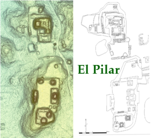
LiDAR, which stands for Light Detection and Ranging, is a remote sensing method that uses light in the form of a pulsed laser to measure ranges (variable distances) to the Earth. These light pulses—combined with other data recorded by the airborne system— generate precise, three-dimensional information about the shape of the Earth and its surface characteristics. LiDAR technology is being highlighted in the news as this accurate and detailed imagery reveals long-lost archaeological sites. LiDAR is unveiling immense sites hidden in the lush forest--Terraces at Caracol, major temples in Honduras, and now a city of grand proportions in Cambodia. Though these discoveries are important, the continuing challenge with LiDAR data is to understand the subtlety and the nuances of the landscape. This is what we are doing at El Pilar where most of the major architecture has been mapped by traditional archaeological survey methods. We are now looking to understand the land use patterns of the Maya houses and forest gardens that underwrote the prosperity of the city.
With a generous donation of LiDAR data from Mayaniquel/Anfield Nickel that covered the 8 square miles of the binational El Pilar Archaeological Reserve for Maya Flora and Fauna, we used raster elevation models to scrutinize the imagery of the areas surrounding major monuments. This is the perfect project in which to develop the field strategies for this novel technology. We can highlight targets on the LiDAR image and use the Global Positioning System (GPS) to validate the location in the field.
At each location we itemized the local trees, recorded the nature of the terrain, and listed the nature of the canopy and understory to compare with the LIDAR data itself. This information is now being compiled into our Geographic Information System at UC Santa Barbara known as the Maya Forest GIS. From these data we will be able to use LiDAR technology to compare and contrast field verification of cultural characteristics, natural features and vegetation. These methods will also give us a better understanding of how we can use LiDAR in our future field projects.
GPS
Though LiDAR in combination with GIS produces detailed and accurate layered maps of images beneath the canopy, it is important to verify these structures and features in the field. Using our survey maps of the residential zones and LiDAR models, we are able to identify areas for survey with coordinates that we plug into our GPS units, and thus we can verify the exact locations of archaeological discoveries.